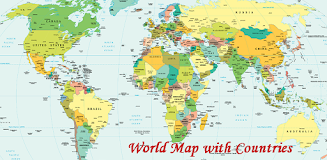
Explore the world's geography with ease using the World Map With Countries app! This app offers a clear and comprehensive view of global political and geographical boundaries, making it a valuable resource for anyone interested in learning more about our planet.
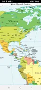
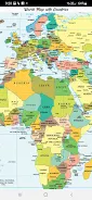
The app provides a detailed visual representation of continents, countries, territories, oceans, seas, and islands. It also includes meridians and parallels, illustrating the geographic coordinate system. This detailed political map highlights the administrative boundaries of all countries, showcasing the intricate relationship between geography and political divisions.
Key Features:
- Visual Clarity: The app's intuitive design makes understanding geographical locations and boundaries simple and straightforward.
- Comprehensive Coverage: Explore all continents and countries, including transcontinental nations, and various territories and islands, both large and small.
- Geographic Coordinates: Learn about the geographic coordinate system through a clear depiction of meridians and parallels.
- Political Boundaries: Gain insight into the world's political landscape through the precise display of administrative boundaries.
- Educational Resource: Discover detailed information about 197 countries, including their borders and surrounding water bodies.
- User-Friendly Design: Enjoy an easy-to-navigate interface that makes exploring the world map a pleasure.
In Conclusion:
The World Map With Countries app is a must-have for students, travelers, and anyone seeking a deeper understanding of global geography and politics. Its user-friendly design, comprehensive data, and visually appealing presentation make it an excellent tool for learning and exploration. Download the app today and begin your global adventure!